Enrich DEM
Overview
➡️ Insert altimetric points coming from input layers into the input DEM. This script works with five input layers:
Digital Elevation Model (DEM) to be enriched
Orographic lines
Hydrograpic network
Roads
Railways
And six parameters:
Road width (roadWidth): Name of column where the road width is stored (Mandatory)
Roads platform height (hRoad) (Optional). Default value = 0m
Railroads right-of-way (railWidth): Name of column where the railroad right-of-way is stored (Mandatory)
Rail platform height (hRail) (Optional). Default value = 0.5m
Input SRID (inputSRID): SRID of the input tables (Optional)
Output suffixe (outputSuffixe): Suffixe applied at the end of the resuling table name (Optional). If not specified, “ENRICHED” is applied
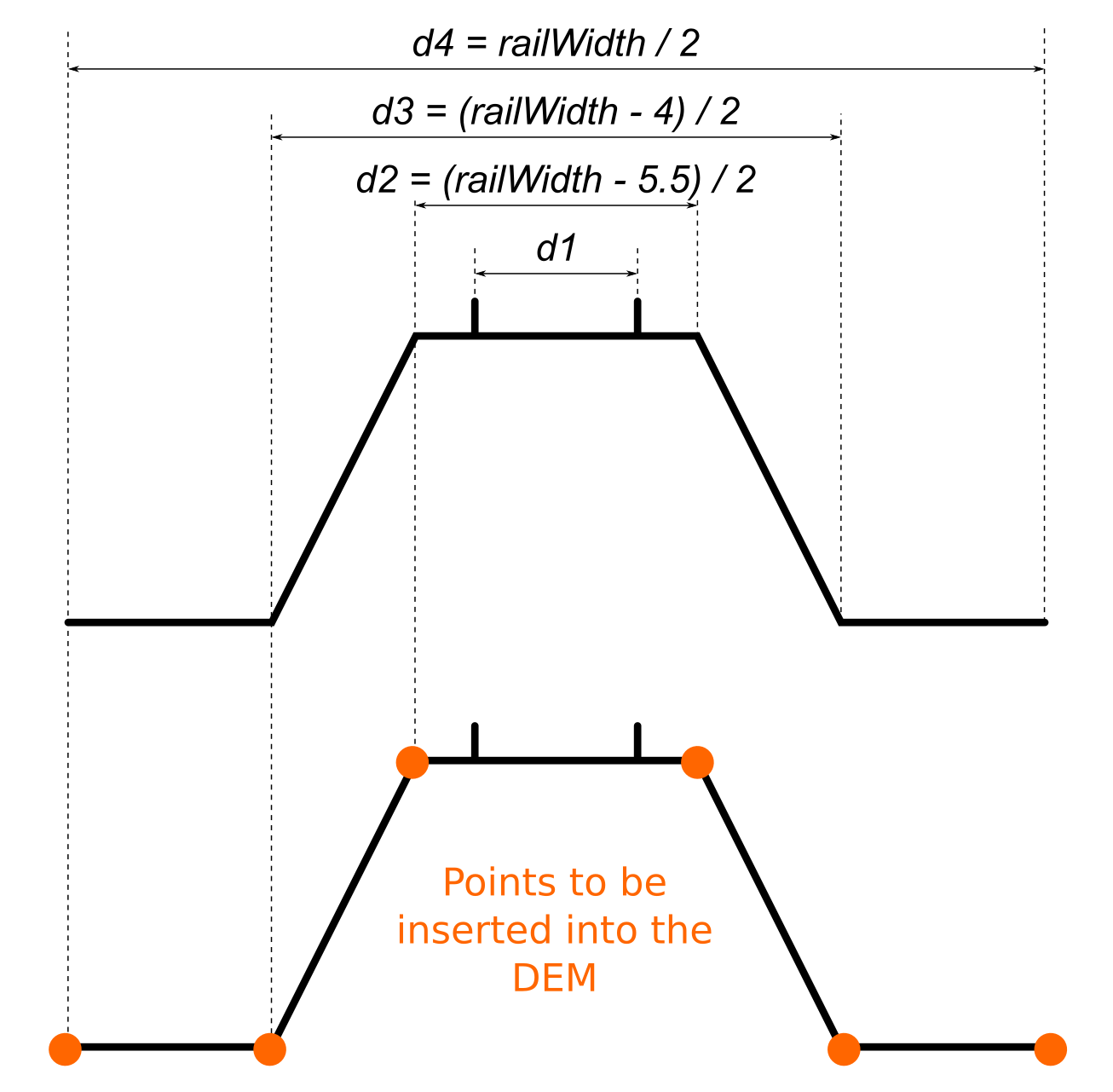
In the schema below, orange points will be inserted into the DEM. d2, d3 and d4 are deduced from the information provided in the parameter railWidth, using the following formula:
d2 = (railWidth - 5.5)/2
d3 = (railWidth - 4)/2
d4 = (railWidth)/2
Arguments
Mandatory inputs
inputDEM— Input DEM tableName of the input DEM table to be enriched
Type:
StringinputHydro— Input hydrographic tableName of the input hydrographic network table
Type:
StringinputOro— Input orography tableName of the input orography table
Type:
StringinputRail— Input railways tableName of the input railways table
Type:
StringinputRoad— Input roads tableName of the input roads table
Type:
StringrailWidth— Railways widthName of column where the railways width is stored
Type:
StringroadWidth— Road widthName of column where the road width is stored
Type:
String
Optional inputs
hRail— Railways platform heightRailways platform height (in meters) (Optional)
Type:
doubleDefault:
0.5hRoad— Roads platform heightRoads platform height (in meters) (Optional)
Type:
DoubleDefault:
0inputSRID— Input SRID🌍 SRID of the input tables. 🛠 If not specified, the SRID from DEM layer is applied. If DEM has no SRID, 0 is applied
Type:
IntegeroutputSuffixe— Output suffixSuffix applied at the end of the resulting table name
Type:
StringDefault:
ENRICHED
Output
result— Result output stringThis type of result does not allow the blocks to be linked together.
Type:
String